The trail
-
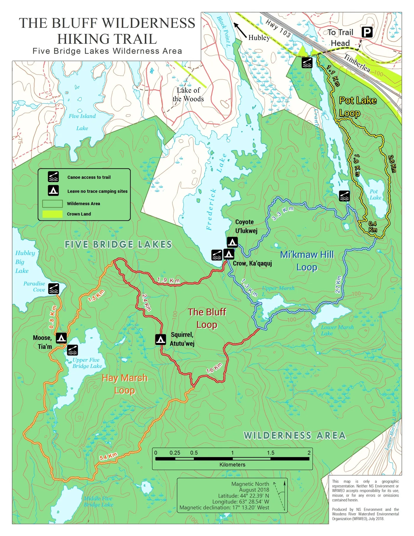
Official Bluff Trail map
Produced by NS Environment and WRWEO. Printable at 9.5 × 7″, 200 dpi. Also on the maps and distances page with the full distance table.
- Full Bluff Trail GPX track
- Canoe access points and portage routes
-
Five Bridge Lakes Wilderness Area walking guide
Five Bridges Wilderness Heritage Trust. Includes The Bluff Trail, the ATVANS/NSORRA routes and Joshua Slocum Road.
-
A Guide to the Trails of the Woodens River Watershed
Based on the summer work of students, initiated and supervised by WRWEO with government funding.
Studies from the trail
- New kingdom of life identified from dirt found on The Bluff Trail
-
Unique Forest Assessment Report
Mike Lancaster, Bluff Trail Stewardship Coordinator.
-
Sediment analysis of the Woodens River watershed: microplastic pollution and macroinvertebrate health
Laura Struthers and Logan Hunter, NSCC, April 2018. Posted with the authors' permission.
-
Bluff Wilderness Hiking Trail stewardship report
Devon J. Harlow-Gillighan, Saint Mary's University ENVS 4499, 6 May 2017.
- Natural history hike on The Bluff Trail
-
Human waste study
Commissioned by WRWEO from Acadia University: the rate of decomposition and degree of spread of human waste from hikers over time.
Archived documents
Older documents with archival value.
-
A Guide to the Trails of the Woodens River Watershed
A 27-page pamphlet with maps and descriptions, prepared in 1996 by the Woodens River Environmental Action Team — John Danson, Michelle Doucette, Neal Lade and Anne Reyner. It may be downloaded for personal use. Note that some of the trails may since have become overgrown or otherwise changed, and that the document predates The Bluff Trail.
-
Important projects successfully undertaken by WRWEO, 1995–2014
The record of conservation, trail, organization and watershed work, last updated 6 March 2014. Presented in readable form on the about page.
Stewardship reports
Every Bluff Trail Stewardship Program year-in-review report since the program launched in 2017 is listed on the stewardship page. AGM agendas, minutes and financial statements are on the governance page.
Watershed maps
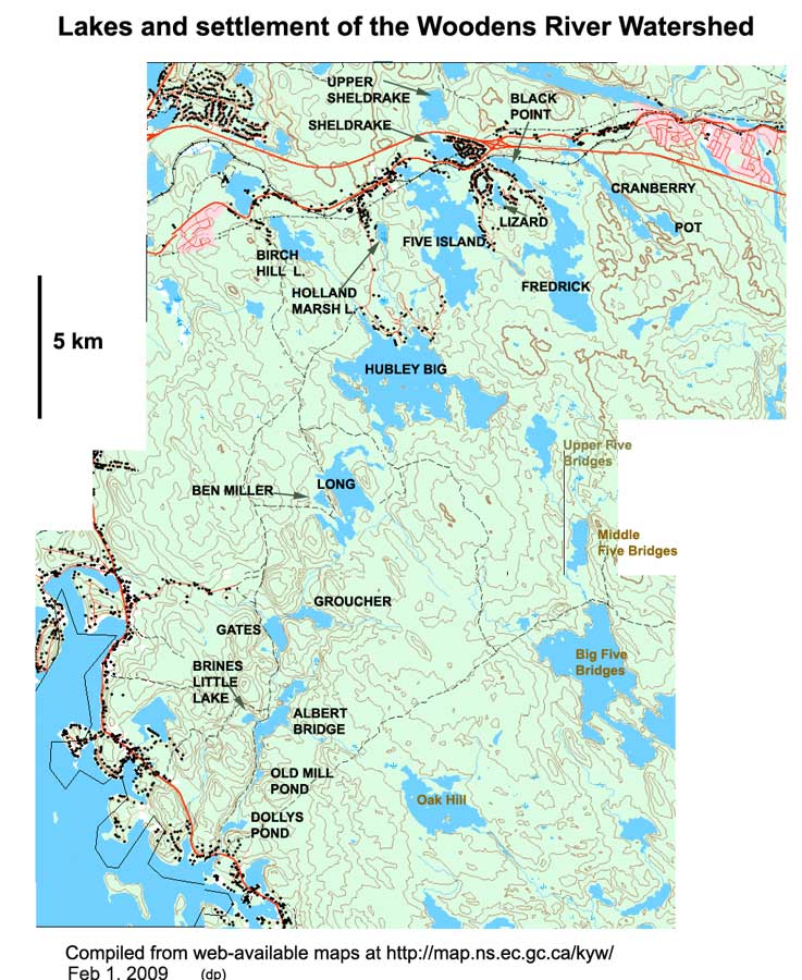
- Lakes and settlement of the Woodens River watershed
- Flowchart for lakes in the Woodens River watershed
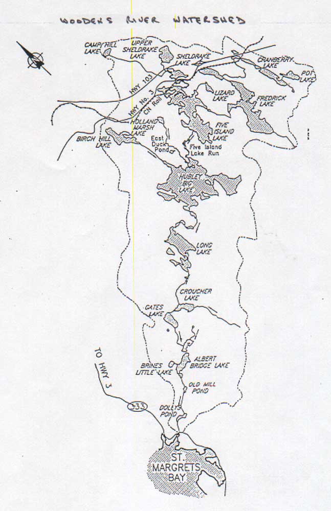
- Woodens watershed lakes
Hand-drawn sketch by Frank Hope.
- Watershed topographical map
- Major watersheds of the Five Bridge Lakes protected area
- Lands protected from development on the Chebucto Peninsula
Existing and proposed protected lands, and potential wildlife corridors.
- Soils map for western HRM (Chebucto Peninsula)
- Land use map for the Chebucto Peninsula
- Five Bridge Lakes Wilderness Area boundary map and designation documents
Nova Scotia Environment.
Water quality
Water quality here means the physical, chemical and biological characteristics of the water, measured against the needs of the organisms living in and drinking it. For the Woodens River system the reference condition is somewhat acidic, nutrient-poor, and high in humic acids, which colour it brown. See also the asterisked items under fish and fish habitat, which carry water quality data.
-
Sediment analysis of the Woodens River watershed: microplastic pollution and macroinvertebrate health
Laura Struthers and Logan Hunter, NSCC, April 2018. Posted with the authors' permission.
-
Macroinvertebrates as bioindicators, and microplastics in sediment
Kathleen Hipwell, NSCC.
-
Acid rain on the Woodens River watershed, November 2010 – October 2011
Observations and comments by WRWEO volunteer Bob Chambers.
-
A comparative study of water quality in selected lakes of the Woodens River watershed
Bob Chambers for WRWEO. Oxygen, temperature, phosphorus, Secchi disk, chlorophyll a and colour for eight lakes — Cranberry, Black Point, Frederick, Five Island, Hubley Big, Long, Sheldrake and Birch Hill — taken 2000–2002.
-
Algal blooms in the Woodens River watershed
Background on algal blooms, Bob Chambers's observations of blooms on Black Point Lake, and a request to report them.
-
Sheldrake Lake monitoring report
Bob Chambers on how well the hypolimnetic aeration system is working and the long-term trend in lake phosphorus.
-
Sheldrake Lake Hypolimnetic Aeration Project: a technical overview
The Ashley report, prepared for WRWEO, 6 October 2001.
-
HRM lakes and rivers
Reports of lake water quality over recent years. Lakes sampled in the Woodens River system include Black Point, Hubley Big and Sheldrake.
-
Nova Scotia's water portal
Technical reports, datasets and maps from the province.
-
Nova Scotia lake inventory maps
Maps are available for Five Island Lake, Hubley Big Lake and Sheldrake Lake.
-
Assessment of long-term changes in water quality from Halifax region lakes using paleolimnological techniques
MSc thesis, T. Rajaratnam, Queen's University. Sheldrake Lake is one of 51 lakes sampled; diatom assemblages from the top and bottom of a core give evidence of nutrient enrichment since pre-industrial times.
- Halifax Regional Watersheds Advisory Board
-
Community-Based Environmental Monitoring Network
Assists individuals, community groups and organizations in starting environmental monitoring in Nova Scotia.
-
Groundswell: community-based groundwater monitoring
An Ecology Action Centre project installing dataloggers in unused wells to monitor water levels.
Fish and fish habitat
-
Focus on fish and fish habitat — WRWEO Watch
An overview of the issues in the Woodens River system. In an essay titled “Where have all the mayflies gone?”, Bob Chambers examines possible explanations for the precipitous decline of the spring mayfly in 1989–90 and the near-simultaneous decline of the brook trout.
-
An integrative approach to prioritizing aquatic habitat restoration sites in the Woodens River watershed
Saint Mary's University honours geography thesis by Oliver C. Woods, on brook trout habitat. Posted with the author's permission. Abstract.
-
Habitat survey of the Woodens River watershed
Three young people carried out baseline habitat and water quality studies of streams throughout the watershed — vegetative cover, pH, invertebrates.
-
Woodens River watershed resource analysis
Elizabeth Tough, NSCAD Environmental Planning Studio 1, for the Three Brooks Homeowners Association. An overlay analysis of vegetation and land use, soils, slope aspect, hydrology, geology and elevation to define sensitive areas for brook trout habitat.
-
Five Island Lake remediation
The lake was contaminated by PCBs in the mid-1990s and a cleanup was subsequently conducted. Jacques Whitford / Stantec reports, including 2007 fish monitoring results (PDF) and the 2008 fisheries resource study (PDF), which includes lake pH data.
-
2009 Stantec report on biological and supporting water quality studies, Woodens River watershed
Water chemistry, benthic invertebrate communities in spring, and observations of brook trout spawning areas in autumn.
-
Report on perch in Long Lake (Woodens River)
Cathy Munro and John MacMillan, Nova Scotia Fisheries and Aquaculture.
-
Brook trout population parameters from angling catch, Big Five Bridge and Moores Lake, 2004
Tara Crandlemere, Nova Scotia Fisheries and Aquaculture.
-
Fish habitat and electrofishing results for the Sheldrake Lake tributary
Pages from the Highway 113 environmental assessment.
- How are the mayflies doing?
-
Reversing the decline of Nova Scotia's wild brook trout: a discussion paper
Originally published by Trout Nova Scotia, which has since folded.
-
Nova Scotia sportfishing and the angler's handbook
The Woodens River system is a catch-and-release Special Trout Management Area. Confirm the current rules before you fish.
- Nova Scotia trout management plan
- Nova Scotia Adopt-a-Stream program